Find the right balance between risk, cost and business performance.
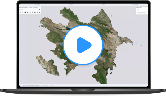
LAND CADASTRE & REGISTRY
LAND CADASTRE & REGISTRY
LAYERMARK created a web-based fully integrated Land Cadaster & Registry System (TEKUIS) that uses intelligent targeting and geo-processing algorithms to optimize the determination, protection, operation, and planning tasks for agricultural and cadastral land. Actively used in the Republic of Azerbaijan, 8 million hectares of land is integrated in 2020.
Integrated with the national ID registration system, users can view additionally the owner/ holder history of each parcel. Over 10 million citizens of Azerbaijan benefit from this project. We state that a sustainable and efficient use of national resources significantly increases the country’s productivity and GNP as seen in Azerbaijan.

SOIL MANAGEMENT SYSTEM
SOIL MANAGEMENT SYSTEM
The outputs of our integrated Soil Management System are utilized across the critical decision landscape such as the leasing of fertile lands, combating desertification, and the deployment of irrigation technologies and methods.

GEOBOTANIC MANAGEMENT SYSTEM
GEOBOTANIC MANAGEMENT SYSTEM
This web-based GIS Application empowers users to make the optimal determination, protection, operation, and planning for grassland areas and feeding capacity.

LAND VALUATION SYSTEM
LAND VALUATION SYSTEM
LAYERMARK’s Land Valuation System determines and evaluates the best use status for areas that are not suitable for agriculture or animal husbandry so that they can be operated for other purposes.

EXPROPRIATION SYSTEM
EXPROPRIATION SYSTEM
In cases of eminent domain, (obtaining private property for government use) for freeway/road expansion, our GIS-based Expropriaton System allows users to create reliable and accurate maps. We provide authorities the data so fundamental to knowledge-based decision making.
FIELD MOBILITY SOLUTIONS

With our visual and map-based applications, it is easier to obtain accurate and reliable data on location-aware smartphones. It can work both online and offline. This application provides an optimized multiple-system integration between ESRI and a company’s databases without exhausting the system resources.
KEY FEATURES
BETTER MANAGEMENT AND CONTROL OF LANDS IN THE COUNTRY

USER FRIENDLY INTERFACE
Interface designed with the needs of the end user in mind.

SAFETY FIRST
Transparent System – No loss of data

WORKFLOW MANAGEMENT SUPPORT
Management of different user groups
RELIABLE DOCUMENTATION
Created as a useful communication and information system.

FLEXIBILITY
TEKUIS can be integrated and extended with external software.

SERVICE SUPPORT (API) FOR THE 3rd PARTY
3rd party software can access to any information by using TEKUIS services.

ORGANIZATIONAL PERFORMANCE MANAGEMENT
Prevention of duplication and complexity of information for effective performance management.
CORPORATE DATA MANAGEMENT INFRASTRUCTURE
Automated and reportable Workflows

MULTIPLE LANGUAGE SUPPORT
TEKUIS supports different language options for end users.